Västervik, SE · 57.76°N
Marine archaeology field study · 2011–ongoing

The methodthat changed marine archaeology.

King Erik XIV's flagship Mars sank in 1564 and was rediscovered in 2011 — where the method was born.

Visualization based on Ocean Discovery's photogrammetry of the warship Mars.

← All projects
Mars Makalös
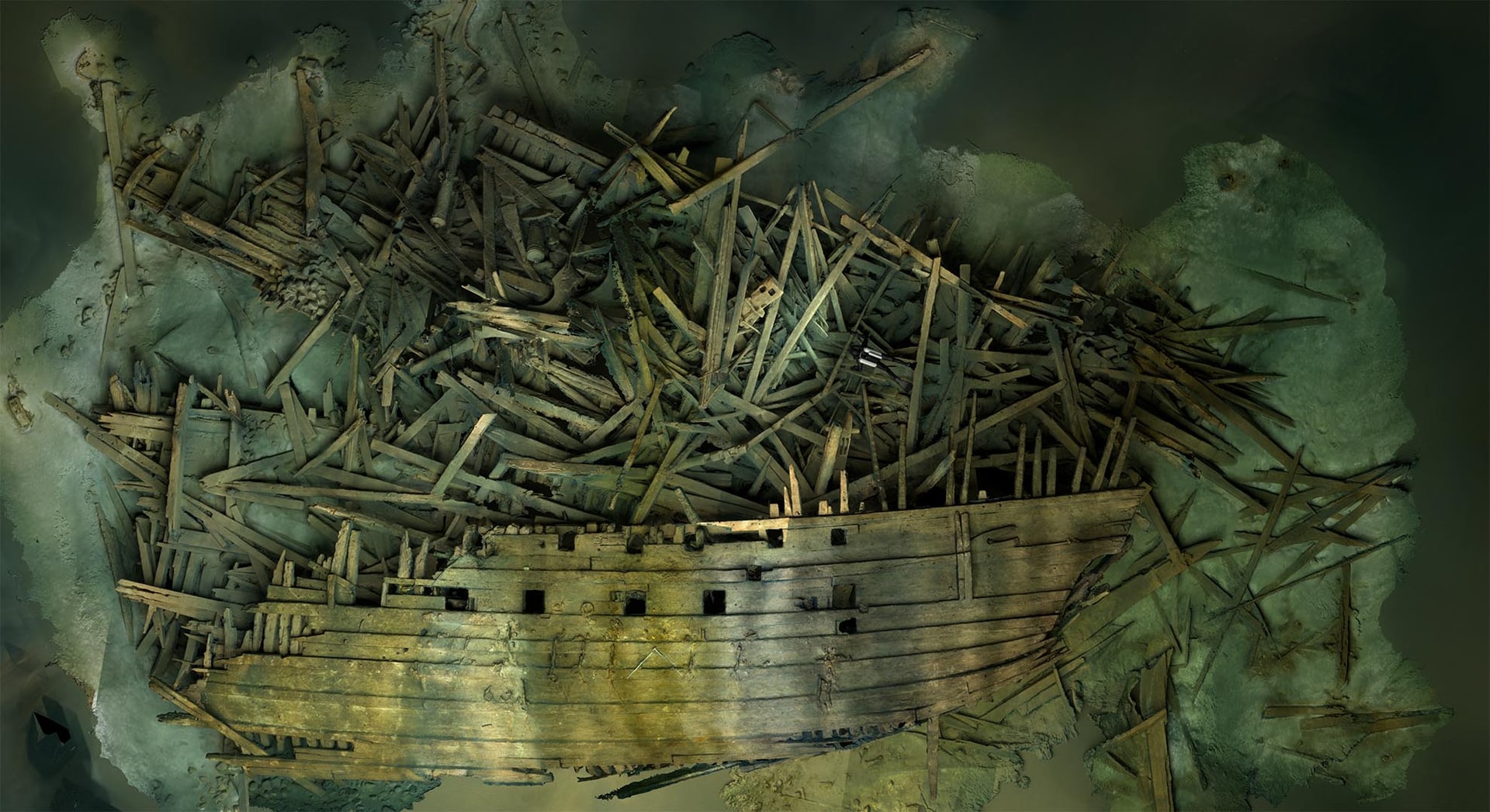
Photogrammetric 3D model of the Mars wreck site — geometrically accurate reconstruction based on more than 50,000 photographs.

Mars — or Makalös ('peerless') — was King Erik XIV's flagship, the largest warship in the Baltic when it sank on 31 May 1564 in the First Battle of Öland. Around 900 men on board, more than 120 cannons, 48 m long — larger than Vasa. Cannon fire from Lübeck-German forces reached the powder magazine and Mars exploded.

For twenty years, brothers Richard and Ingemar Lundgren together with Fredrik Skogh searched for the wreck — driven by a childhood fascination kindled at the Vasa museum. In the summer of 2011, the wreck was located with side scan sonar at 75 metres depth, 12 nautical miles northeast of Öland. The identification was confirmed later the same year by Erik XIV's coat of arms with the double Vasa-sheaf on one of the cannons. Mars was the genesis of Ocean Discovery's photogrammetry. The scientific research is led by professor Johan Rönnby at MARIS, Södertörn University, in collaboration with the Swedish Defence University, MMT and Ocean Discovery. The Baltic Sea Foundation, the National Geographic Society and The Explorers Club fund the project.

— Mars in numbers

Sank
1564

31 May — First Battle of Öland.

Depth
75m

12 nm NE of Öland.

Length
48m

Larger than Vasa.

Cannons
120+

Most heavily armed warship of its era.

Hull preserved
2/3

Port side and sterncastle intact.

Case study 01

Twenty years of searching

It all began with a childhood visit to the Vasa museum in Stockholm. Richard and Ingemar Lundgren set the goal: find Mars Makalös. Together with Fredrik Skogh they spent two decades on systematic side scan surveys of the Baltic seabed off Öland — without finding the wreck.

They became technical divers precisely to be able to reach Mars one day. By the time the wreck was found in 2011, they had already built up the technology required to document it safely.

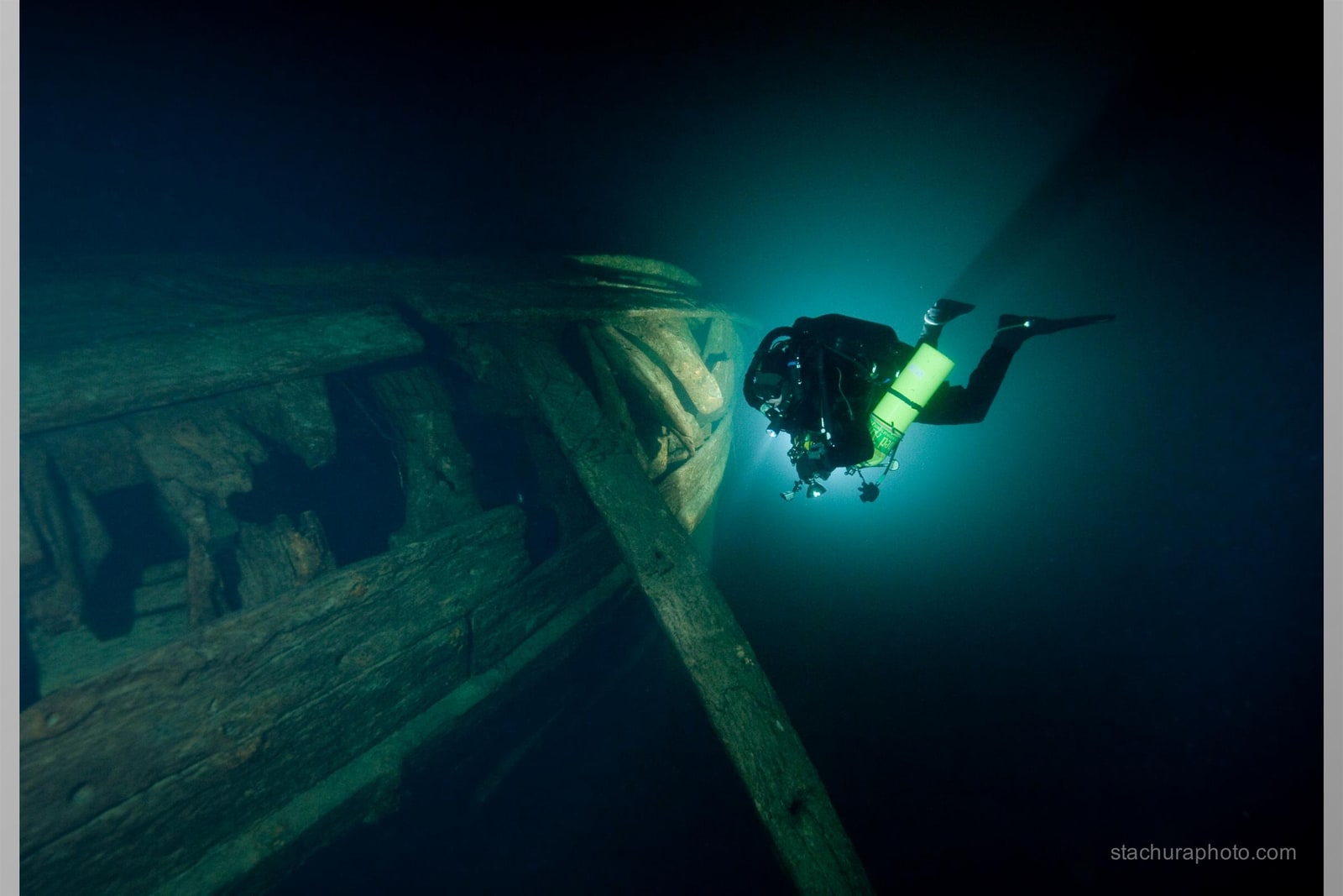
Technical diver beside the Mars wreck's bow at 70 metres depth, photo by Tomasz Stachura

Case study 02

The wreck is found — summer 2011

In the summer of 2011, an irregular wreck anomaly was registered with side scan sonar approximately 12 nautical miles northeast of Öland. In October the same year, the first ROV survey was conducted together with MARIS, the Swedish Defence University, the Maritime Museum and Kalmar County Museum. The identification was confirmed by Erik XIV's coat of arms with the double Vasa-sheaf on one of the scattered cannons, and by linking a unique 20-pound culverin to Mars's roster from May 1564.

The wreck lies at 75 metres depth, with its shallowest point on the port side at 66 m, surrounded by scattered objects and fragments out to about a 100 m radius. About two thirds of the hull is preserved on the bottom thanks to the Baltic Sea's low salinity — including the large sterncastle that shows Swedish great-ship construction from the era of Gustav Vasa and Erik XIV.

Case study 03

From Stachura's mosaic to world-leading photogrammetry

Ocean Discovery began testing photogrammetry on smaller objects — cannons, carriages, individual details on the wreck. It worked. The next step was attempting to model the entire wreck. It took several years and required an international team of technical divers. Each dive was limited to 20–30 minutes of bottom time at 70 metres depth in total darkness, with flash light reaching no more than two metres.

Once the method was proven, Ocean Discovery equipped an ROV with the same cameras and methodology divers had used. That opened the door to depths, environments and wrecks divers could never safely reach. The experience from Mars is the basis of Ocean Discovery's work today — from M/S Estonia to HMS Cassandra.

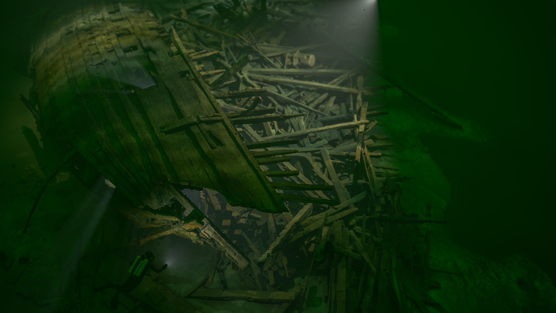
Cinematic 3D rendering of the Mars stern
Cinematic 3D rendering of the Mars stern — the photogrammetry model visualised with computer-generated lighting, volumetric light and simulated underwater effects.

Case study 04

The scientific team

The Mars project is scientifically led by professor Johan Rönnby at MARIS, Södertörn University. Niklas Eriksson has provided the ship-archaeological analysis and Ingvar Sjöblom of the Swedish Defence University has identified the cannons. The Mars wreck was rediscovered in 2011 after two decades of joint searching by Richard Lundgren, Ingemar Lundgren and Fredrik Skogh. Ocean Discovery has since formed the project's operational core: development of photogrammetry at extreme depth as a method, fieldwork and technical diving at 70 metres depth. The international dive team captured 50,000+ photographs; Ingemar Lundgren has carried out all post-production and built the 3D model on which the scientific reconstruction rests. Results have been published in three field reports (2012, 2013, 2015) and in peer-reviewed articles in the International Journal of Nautical Archaeology.

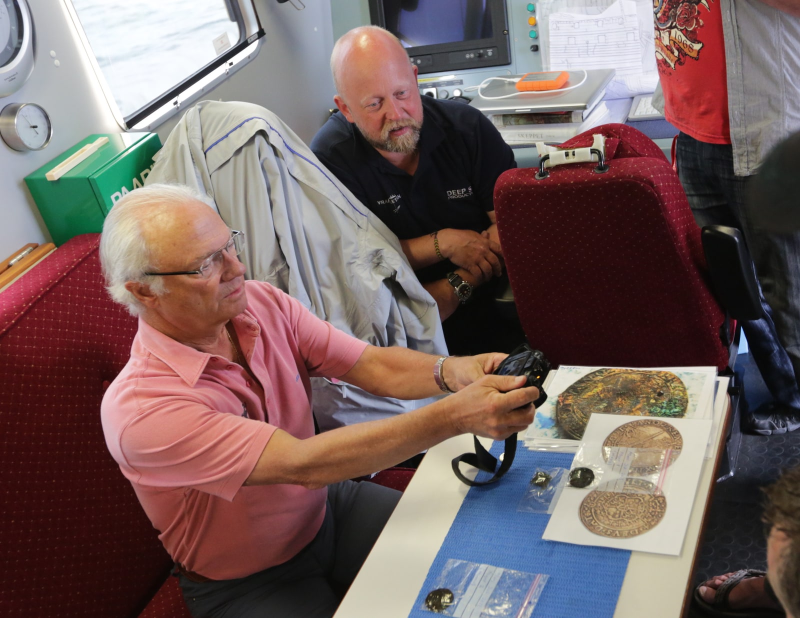
During Phase II in 2012, around 30 people from Sweden, England, the USA, Poland, Norway and Denmark took part, deployed across three vessels. 94 dives were carried out, 47 hours were spent on the wreck and 141 hours in decompression. His Majesty King Carl XVI Gustaf visited the field work on board in 2012, photographed one of the recovered silver coins and met the Mars team. The coins were later analysed by Kenneth Jonsson at Stockholm University.

The project has also been portrayed on film. Deep Sea Productions documented the work in "Mars the Magnificent — Battle of Giants" (also known as "Mars Makalös" in Swedish), 60 minutes, co-produced with SVT, ZDF and ARTE and premiered in 2015. The film follows both the ship-archaeological research and the dive team's work at 75 metres depth.

King Carl XVI Gustaf photographs one of the silver coins from Mars Makalös on board the survey vessel during Phase II in 2012.
His Majesty King Carl XVI Gustaf photographs one of the recovered silver coins from Mars Makalös, Phase II 2012.

Case study 05

From digital to tangible — Västervik Museum

Ocean Discovery collaborated with Västervik Museum to build the exhibition "Ships of the Vasa Kings — the maritime 16th century" where Mars Makalös is the centrepiece. Visitors today can virtually dive to the wreck with VR goggles — move across the soot-blackened oak timbers at 75 metres depth without leaving the museum.

The photogrammetric models have also been 3D-printed as physical scale models that visitors can touch. The combination of digital and tactile experience turns an inaccessible wreck into something visitors can study in detail and physically handle. The exhibition is a collaboration between Västervik Museum, MARIS, the Swedish Defence University, Stockholm University and Ocean Discovery.

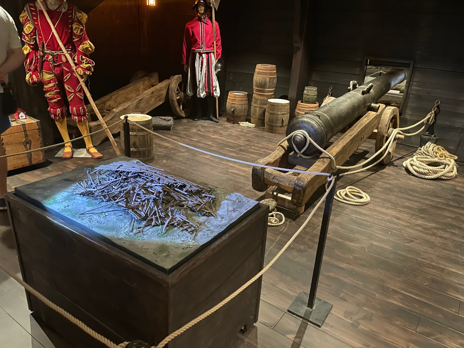
3D-printed model of the Mars wreck site on display at Västervik Museum, alongside a full-scale replica of a Mars cannon
Top-down detail view of the printed and painted model — showing the scattered timbers and hull construction.
Scale miniature divers on the printed model — showing the size of the wreck relative to a diver.

Timeline 1561–ongoing

  1. 1561

    Commissioned by Erik XIV

    Construction begins. Mars is planned as the largest and most heavily armed warship in the Baltic.

  2. 1563

    Launched

    Mars is launched. More than 120 cannons, 48 m long, around 900 crew.

  3. 1564

    First Battle of Öland

    31 May — Lübeck-German cannon fire reaches the powder magazine and Mars explodes. Around 900 men perish.

  4. ~1991

    The search begins

    The Lundgren brothers start looking for Mars.

  5. 2011

    The wreck is found

    Summer 2011: the wreck is located with side scan at 75 m depth. In October: ROV survey and identification via Erik XIV's coat of arms.

  6. 2012

    Phase II — the photo mosaic

    94 dives, 47 h on the wreck. Tomasz Stachura composites 600+ stills into the mosaic that lands on the Nat Geo cover and centrefold in 20+ languages.

  7. 2013–2014

    The photogrammetry breakthrough

    Ocean Discovery tests and develops automated photogrammetry — first small objects, then the entire wreck. National Geographic Waitt Grant + magazine feature.

  8. 2019

    Västervik Museum opens the exhibition

    "Ships of the Vasa Kings" re-opens with VR diving, 3D prints and Ocean Discovery's photogrammetric models as the base material.

  9. Ongoing

    The debris field grows

    Documentation has expanded to the debris field around the wreck — over 100,000 images in total, and growing.